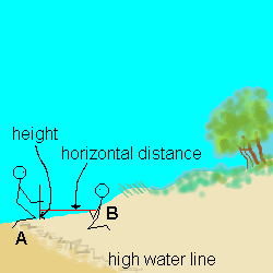
For the Sand Dune Transect
-
Begin at the high water mark.
-
Student A holds the pole/ruler vertical.
-
Student B takes the tape to the first point to be measured (usually the
first "bend" in the profile)
-
Student C (not shown) ensures the tape is horizontal
-
Student D (not shown) records the measurements height and horizontal distance
-
Repeat this procedure at points along the transect, recording your results
as you go.
You can use this Excel spreadsheet to plot a
profile.
Run your mouse along the profile in the diagram to find each of six
points. Click on them to get the measurements.
You can also save it to your hard disk, and use it to help you process
your results after your real trip. |
|